Map of Brooklyn Rare 1908 Antique 22.5" x 32" East New York Van Sinderin Blake +

Map of Brooklyn Rare 1908 Antique 22.5" x 32" East New York Van Sinderin Blake +

Preço normal $230.00 Preço promocional $209.00 Economize 9%
/
  • Carbon neutral
  • Secure payments
  • 1 em estoque
  • Inventory no caminho
Frete calculado no checkout.

This page is from an over 100 year old Atlas made on Linen paper. This item is 100% authentic and well kept. There might be light marks on the very edges of the page. The Map itself from the inner lines as seen in the photos and in excellent condition.

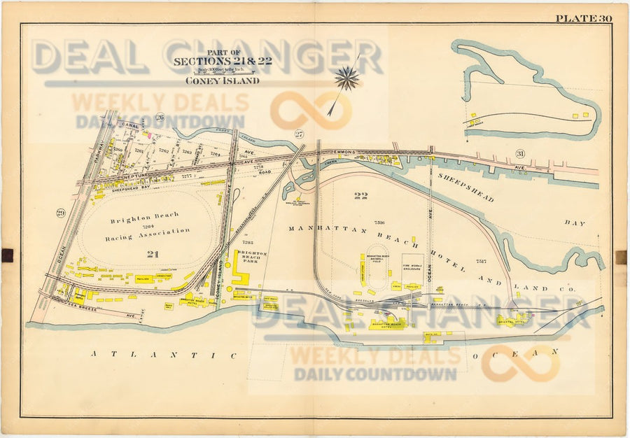
This came from the Atlas of Brooklyn, City of New York - Volume 1.  This map is from the Actual Survey & Official Plans of 1908.  Civil Engineers: George W. and Walter S. Bromley.  Published by G.W. Bromley and Co.  Located printed: 147 N. Fifth Street Philadelphia.

This posting is for an authentic Plate 37 of the Atlas.  The measurements are 22.5" by 32".  The scale is 200 feet to the inch.  There are a visible circle written in pencil shown in the photos.
The title page is listed being shown for reference & viewing purposes only. 

Areas Covered in this posting (Part of Section12):

        • East New York Avenue
        • Eastern Parkway
        • Sutter Avenue
        • Dumont Avenue
        • Belmont Avenue
        • Pitkin Avenue
        • Blake Avenue
        • Rockaway Avenue
        • Livonia Avenue
        • Riverdale Avenue
        • ++++++++

Este site é protegido por reCAPTCHA e a Política de privacidade e os Termos de serviço do Google se aplicam.

Visto recentemente